 (Thanks to Jessica Russell for this post)
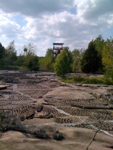
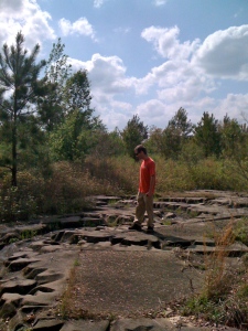
Near the southwest Jackson/Clinton line, a 200-acre oddity of concrete and steel is quietly disappearing into the underbrush. It’s the Mississippi River Basin Model…or at least, what’s left of it. Which, to me, is still pretty impressive, and well worth seeing before nature takes over altogether. It’s a colossal relief map so large, you get to explore it on foot. You can’t see it all from one place, but you can climb the old tower, if you dare (it’s surprisingly sturdy, actually) for a somewhat better view. I for one never quite figured out which end was NOLA and which was St. Louis, but it was fun to guess.
Every part of the river basin’s topography, from the shallowest streams to the deepest channels, floodplains and levees, is sculpted in concrete to an exacting scale. In certain places, groups of metal pegs and mesh wire were deliberately placed along the river bottom. Two theories emerged in our party: simulated debris to mimic natural current  interruptions, or an attempt to prevent the ruins from becoming a sweet stake park. The former turned out to be correct!
Growing up nearby, I had heard stories for years about this place, described as everything from a “defense experiment” to a “prisoner of war camp.” I went to Google to set the record straight – and found a tiny bit of truth behind both tales.
In its heyday, this bizarre construct was a state-of-the-art calculations device. The Army Corps of Engineers designed it specifically to help predict floods, droughts and other conditions throughout the river basin, which incidentally covers 41% of the continental U.S., and even parts of Canada. In 1943, German prisoners of war, handpicked for the project for their engineering backgrounds (and precise nature, no doubt), began the dirtwork. The Corps completed the project over the next several years, calling occasionally on Jackson-area contractors for additional concrete work. What I found most amusing in  my research was a photo in this article < http://misspreservation.com/2010/02/10/before-and-after-mississippi-river-basin-model/ > of the place in its prime. Forget the drive-ins, folks. Apparently, “engineering types” once brought their dates here to impress them with their knowledge of waterways experiments! Smooth.
As you probably guessed, computer modeling replaced the need for physical structures like this. It was abandoned in 1993, but to see it today is still quite the experience. Nowhere else can you follow the twists and turns of the Mississippi and its winding labyrinth of streams and inlets as they carve their way throughout the Mississippi River Basin at the rate of one mile per step. It’s almost like being a giant.
For those who prefer to scan instead of read, these “fun facts” are just for you:
* The largest “small-scale” river basin model ever  built
built
* An entire day on the river could be recreated in just over 5 minutes
* One foot equals 2,000 feet in a horizontal direction (about a mile per footstep)-but only 100 feet in a vertical direction.
* One gallon of water per minute flowing through the model equaled 1.5 million gallons in nature
* It’s located off McRaven Road behind Butts Park (unfortunate name, I know)
* It’s on the national historic register, but currently has no funding for preservation. See it while you still can!

this just keeps getting better. i didn’t know about this place, but i’m going this weekend!
Pingback: Episode 52 Shownotes | Chance of Gaming Podcast
The concrete I observed is solid as a rock. A National Guard troop could have the main Cairo-to-Baton Rouge section reasonably cut back and cleaned up within a week or two as little more than a training exercise. From there the city could renovate the observation tower and charge a buck or two for entry to pay for it. Before long it could become a small tourist attraction again. Just my .02.
I like that idea, Ed. I wonder if the city has the vision or cash to get it rolling.
Mississippi River Basin Model (1969) from Ron Rodenmeyer on Vimeo.
where did you get this film?
Pingback: This abandoned model of the Mississippi River Basin was way more fascinating than it had a right to be – KellyKazek.com